
Hawaiian Archipelago and Star Compass
Print Pagegrade level: 4–6 | subject–history and social studies, science and technology
Time needed
two 45-minute classes
Description
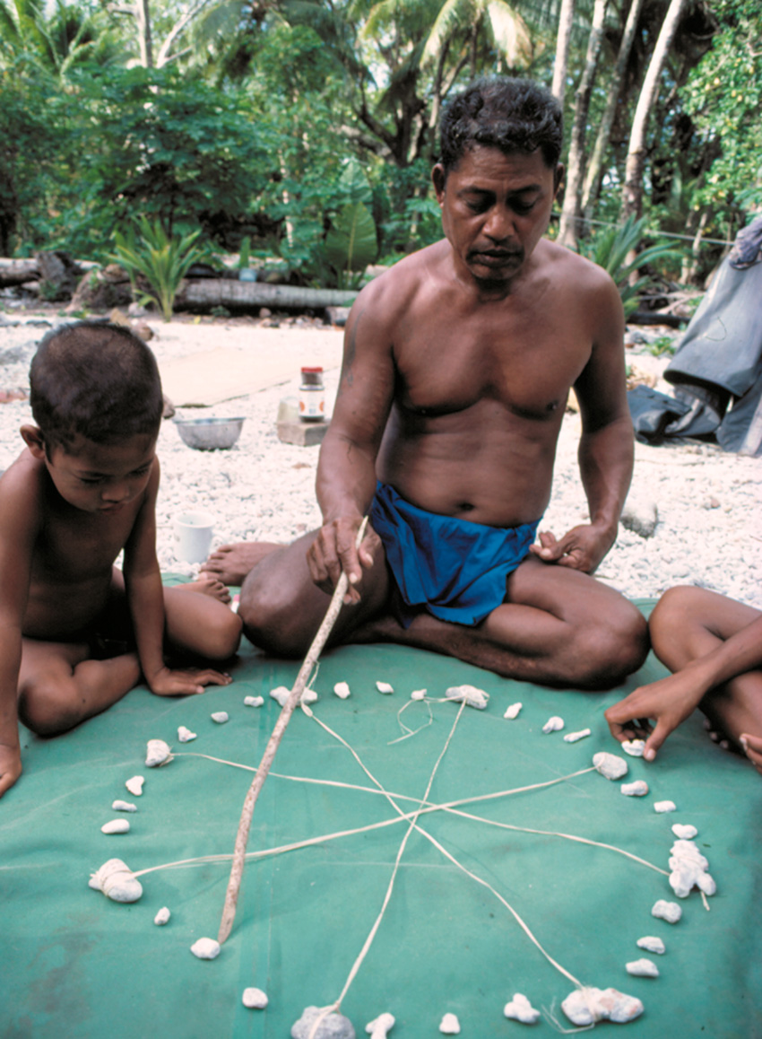
Students use the online exhibition A Voyage to Health and other online materials in learning about the Hawaiian Islands’ geography, geology, and traditional navigation. In Class 1, students view Hawai‘i on a world map and learn about its geography and geology. They also examine when and who first settled on the Hawaiian archipelago. In Class 2, students learn about how the first people traveled to and from the Hawaiian Islands without any instruments. They are introduced to the “Hawaiian Star Compass” developed by C. Nainoa Thompson, the master navigator who is a part of reviving the traditional Polynesian long-distance voyaging. Students explore the types of knowledge that a navigator must have in order to find direction in an open-ocean without instruments. They are then able to connect the voyaging tradition to the health among Hawaiian people. Students also use their mathematical skills to identify angles of constellation noted on the Hawaiian Star Compass.
- learning outcomes
Students will be able to:
- Identify the Hawaiian Islands on the world map and locate other islands in the Pacific Ocean, e.g., Marquesas Islands and Tahiti.
- Explain how and when the Hawaiian Islands were formed, what they consist of, who, their first settlers were and how they got there.
- Describe the significance of ancient Polynesian navigation and its importance for the Native Hawaiians.
- Calculate angles when a circle is divided into four and 32 equal parts.
- Estimate angles in a circle without using a protractor.
- background information
The online exhibition A Voyage to Health explores the relationship between the physical health of the land and the spiritual and cultural health of its native inhabitants. By examining events and their consequences on the island of Kanaloa Kaho‘olawe, the exhibition depicts the deterioration of the island due to actions taken by outsiders, the subsequent (and ultimately successful) protests by Native Hawaiians, and the recent revival of the ancient Polynesian wayfinding, or long-distance, open-ocean voyaging without instrumentation in double-hulled canoes. This revival is part of a wider revival of native beliefs, observances, and practices being passed on to younger generations in an effort to heal the land and its people. Teachers are encouraged to preview all sections of the online exhibition.
CloseClose All - vocabulary
The following words may be introduced via direct instruction or vocabulary activity that is incorporated into student activities using the assigned reading materials:
- Native Voices Timeline: Hawaii entries for AD400: Marquesas Islands, archaeological, evidence, poi, pounders
- Native Voices Timeline: Hawaii entries for AD1200: Tahitian, stratified, chiefdoms, enforce, extend, authority, population
- “Introduction” section of A Voyage to Health: navigation, voyaging, voyagers, revived, heritage, generation
- “Journeys through History” section of A Voyage to Health: migrating, observatory, solar, lunar, navigational, navigator, contemporary, planetarium, farthest, latitude, north star, southern cross, constellations, easterly, wayfinders
- “The Legacy Continues” section of A Voyage to Health: navigator, eventually, Satawal, Micronesia, wayfinding, Polynesia, Aotearoa, revival, revitalization, circumnavigate, sustainable
- National Ocean Service. “The Hawaiian Islands were formed by volcanic activity”: tectonic plates, magma, erupt, Pacific Plate, archipelago, extend, atolls, reefs, shoals, seamounts
- US Geological Survey. “Origin of the Hawaiian Islands.”: localities, Aleutian Trench, alignment, Polynesians, tempestuous, geological, fissure, volcanologist, plat tectonic, divergent, convergent, subduction, typified, magma, buoyantly
- materials
Handouts:
- Knowledge Quest: Hawaiian Star Compass (PDF, MS Word);
Teacher’s Knowledge Quest: Hawaiian Star Compass (PDF)
- A display set-up for the class—e.g., interactive whiteboard, computer connected projector, or flip chart/whiteboard
- Internet access to the following websites or equivalent printed resources:
- “Political Map of the World, June 2012” from the Regional and World Maps by CIA Library’s World Factbook website.
- US Census Bureau: Hawaii State & Country QuickFacts
- Native Voices Timeline: Hawaii entries
- A Voyage to Health online exhibition
- Formation of Hawaiian Islands:
- National Ocean Service. “The Hawaiian Islands were formed by volcanic activity.” [vocabulary: tectonic plates, magma, erupt, Pacific Plate, archipelago, extend, atolls, reefs, shoals, seamounts]
- US Geological Survey. “Origin of the Hawaiian Islands.”
[vocabulary: localities, Aleutian Trench, alignment, Polynesians, tempestuous, geological, fissure, volcanologist, plat tectonic, divergent, convergent, subduction, typified, magma, buoyantly - Kahn Academy. “Hawaiian Island Formation”
- Knowledge Quest: Hawaiian Star Compass (PDF, MS Word);
- class 1 procedures
- Display a large world map or the online map, “Political Map of the World, April 2012.” Ask students to identify the US on the map. If needed, prompt students to locate Alaska and Hawai‘i, which are located apart from the other 48 states.
- Use Hawai‘i on the map to model map reading skills in identifying geographic information—e.g., latitude and longitude north of equator and near the Tropic of Cancer on the Northern Pacific Ocean, its proximity to other islands and continents, etc.
- Ask students what they know about the state of Hawai‘i and record their responses on a display board. Review the listed items, correcting any erroneous information. See for class discussion, the “US Census Bureau: Hawaii State & Country QuickFacts” website.
- Display the questions a-c below on a display board, and read them aloud. Tell students that they will work together to find answers to these questions about Hawai‘i:
- When and how did the Hawaiian Islands form?
- What constitutes the Hawaiian Islands?
- When and who first discovered and settled in the islands?
- Pair students and assign each pair the letter, a, b, or c, so the letter designation corresponds to the question that each pair answers.
- Provide online access to or printouts of one of a-c items below according to each student pair’s assigned letter and question—e.g., “a” pairs use the National Ocean Service item a below to answer the question a above:
- National Ocean Service. “The Hawaiian Islands were formed by volcanic activity.” http://oceanservice.noaa.gov/facts/hawaii.html
[vocabulary: tectonic plates, magma, erupt, Pacific Plate, archipelago, extend, atolls, reefs, shoals, seamounts ] - US Geological Survey. “Origin of the Hawaiian Islands.” http://pubs.usgs.gov/gip/hawaii/page07.html
- A Voyage to Health: Introduction & Native Voices Timeline: Hawaii entries
- National Ocean Service. “The Hawaiian Islands were formed by volcanic activity.” http://oceanservice.noaa.gov/facts/hawaii.html
- Have student pairs report back and answer the questions a-c. Record their answers to each question and call out relevant geography content, including the locations of the Marquesas Islands and Tahiti.
- (Optional) Show the “Hawaiian Island Formation” video as a summary of the activity.
- Have students write a summary of what they have learned about the Hawaiian Islands, using the questions and answers that they have worked on during the class. Collect students’ written summaries at the end of the class.
- Class 1 Evaluation: Teachers can assess students’ learning progress through class discussions, pair work, and the written summaries collected at the end of the class.
- class 2 procedures
- Return students’ written summaries from Class 1. Select a couple students to read aloud their summaries as a brief review of what they have learned in the previous class.
- Display a world map and locate the Hawaiian Islands, the Marquesas Islands, and Tahiti. Note the long distance from the Marquesas Islands and Tahiti to the Hawaiian Islands, help students imagine ancient Polynesians navigating the open ocean to travel back and forth between their homes and the Hawaiian Islands.
- Tell students that the traditional ocean voyaging was done without instruments, which has been revived and continues today in Hawai‘i, restoring Native Hawaiian culture as well as improving health among them.
- Display the Hawaiian Perspectives online activity and play the videos of Benjamin B. C. Young and Noa Emmutt Aluli who speak about how traditional activities are important in promoting health among Native Hawaiians today.
- Provide to students an overview of the Polynesian traditional navigation without instruments, using the online exhibition sections, “Journeys through History” and “
The Legacy Continues,” and highlighting the following:
- About the traditional double hulled canoe: Plans for the Hōkūle‘a canoe, ca. 1973; Hōkūle‘a, ca. 1997
- Traditional navigator: Mau Piailug, using a star compass to teach navigation to his son, 1983
- Today’s teaching tool developed by C. Nainoa Thompson:Star compass, 1980
- Group students in pairs and have them explore the “Hawaiian Star Compass” online activity and examine closely the “knowledge” recorded and shared on the compass. Provide students copies of Knowledge Quest: Hawaiian Star Compass where they can record their findings.
- Have several student pairs share answers based on their completed Knowledge Quest: Hawaiian Star Compass worksheet. See suggested discussion notes on Teacher’s Knowledge Quest: Hawaiian Star Compass. Summarize the use of the compass today as a teaching tool for training young navigators who can continue the tradition into the future.
- Incorporate the math activity that reviews angles in a circle. Have students draw a circle with a protractor, ask them to mark four directions or hand out copies of the compass, available online at “Hawaiian Voyaging Traditions: Star Compasses”
by the Polynesian Voyaging Society. As a class, calculate and note the answers to the following questions on the compass:
- What is the total degree of the whole horizon?
- How many equal-distanced areas do the compass divided into?
- By what degree does each area divide the circle/compass?
- Starting 0 degree at the center of ‘Akau (North), move clock-wise and note degrees for the center of each area on the compass.
- Assign each student a star on the compass to estimate its angle (between 0-360 degrees). Have students report back with the estimated angle, and model and correct how the angle of the star is estimated.
- Have students complete an exit card answering the question: What aspects of the ancient voyaging do you find most interesting? Why? Collect students’ completed Knowledge Quest: Hawaiian Star Compass worksheet and exit cards.
- Class 2 Evaluation: Teachers can assess students’ learning progress through class discussions, pair work, completed worksheets, and the exit cards.
- evaluations
- extension activities
- Have students use Plans for the Hōkūle‘a canoe, ca. 1973 and Hōkūle‘a, ca. 1997, as well as conduct additional research in building a one-hundredth-scale model of the double hulled canoe—i.e., overall length of 7.48 inch based on the full overall length of 748 inch.
- Assign students to write a diary for 14 days where they record daily environmental observations and how they are connected, or not, to their daily activities.
- Common Core State Standards: Literacy in History/Social Studies
- Determine the central ideas of information of a primary or secondary source; provide an accurate summary of the source distinct from prior knowledge or opinions.
- Integrate visual information (e.g., in charts, graphs, photographs, videos, or maps) with other information in print and digital texts
- Produce clear and coherent writing in which the development, organization, and the style are appropriate to task, purpose, and audience.
- Draw evidence from informational texts to support analysis, reflection, and research. CloseClose All
- Common Core State Standards: Mathematics
Standards for Mathematical Practice (http://www.corestandards.org/Math/Practice):
- CCSS.Math.Practice.MP1 Make sense of problems and persevere in solving them.
- CCSS.Math.Practice.MP2 Reason abstractly and quantitatively.
Geometric measurement: understand concepts of angle and measure angles.- CCSS.Math.Content.4.MD.C.7 Recognize angle measure as additive. When an angle is decomposed into non-overlapping parts, the angle measure of the whole is the sum of the angle measures of the parts. Solve addition and subtraction problems to find unknown angles on a diagram in real world and mathematical problems, e.g., by using an equation with a symbol for the unknown angle measure.
- National Center for History in the Schools: Historical Thinking Standards
http://www.nchs.ucla.edu/
Historical Comprehension:- Draw upon the visual, literary, and musical sources including: (a) photographs, paintings, cartoons, and architectural drawings; (b) novels, poetry, and plays; and, (c) folk, popular and classical music, to clarify, illustrate, or elaborate upon information presented in the historical narrative.
- Consider multiple perspectives of various peoples in the past by demonstrating their differing motives, beliefs, interests, hopes, and fears.
- Obtain historical data from a variety of sources, including: library and museum collections, historic sites, historical photos, journals, diaries, eyewitness accounts, newspapers, and the like; documentary films, oral testimony from living witnesses, censuses, tax records, city directories, statistical compilations, and economic indicators.