ackground
A federal law called the Emergency Planning and Community Right to Know Act (EPCRA) requires facilities in certain industries which manufacture, process, or use significant amounts of specified toxic chemicals, to report annually on their releases of these chemicals. The reports contain information about the types and amounts of toxic chemicals that are released each year to the air, water, and land as well as information on the quantities of toxic chemicals sent to other facilities for further waste management. The U.S. Environmental Protection Agency (EPA) collects this information as the Toxics Release Inventory (TRI). NLM's Toxicology and Environmental Health Information Program (TEHIP) provides access to the data through a series of databases (from 1987 to 2002, the most current year available) within TOXNET.
TOXMAP
NLM is interested in exploring new ways to facilitate more effective understanding of its database contents, including investigation of new data presentation techniques and integration of data from different health data sources. Its Geographic Information System (GIS), called TOXMAP, uses maps of the United States to show locations where companies are releasing specific chemicals. TOXMAP integrates the map display with access to relevant bibliographic references and other data on the TRI chemicals, providing a map-based portal to these resources.
Objectives
TOXMAP is designed to:
- Show the geographic distribution of releases by chemical
- Show how the amount of chemical releases have changed over time
- Use chemical and geographic terms from the displayed map to search bibliographic databases
- Link to chemical information in TOXNET's Hazardous Substances DataBank (HSDB) and other authoritative resources
- Integrate geographically coded data from other sources
- Provide general information about GIS, data quality, and map interpretation
- Make information easy to navigate and understandable to those unfamiliar with GIS
TOXMAP FAQ
Because many users may not be experienced in reading maps or understanding map data, TOXMAP provides Frequently Asked Questions (FAQ) to supplement the user's ability to understand the map displays and data. The initial release of TOXMAP includes questions from "What is GIS?" and "What is TOXMAP?" to "How accurate is TRI Data?" and "What are some tips for reading maps critically?"
Custom Maps
TOXMAP allows users to create nationwide or local area maps that show where chemicals are released into the air, water, and ground, and also provides region-specific links to chemical and bibliographic information. The following scenarios help to illustrate the application's capabilities.
Examples of TOXMAP use:
Scenario 1: Releases
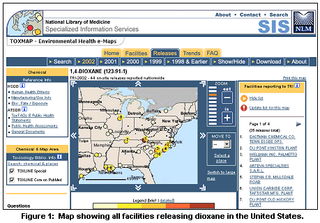
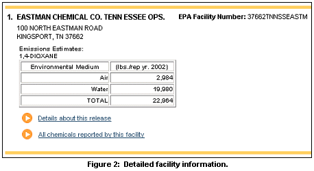
A public health professional is reading about a particular chemical (dioxane) in HSDB and wants to investigate where it was released in the southeastern United States. After entering "dioxane" in the Quick Search box on the TOXMAP homepage, a map is generated showing all the facilities releasing dioxane in the United States (see Figure 1). She zooms in on an area showing a large amount of chemical release. (Sites are color-coded by amount released.) She then selects a facility from the list to the right of the map (if the list is not shown click on the link "Identify releases on this map") that reported releasing a large amount of dioxane to find more detailed information (see Figure 2).
Scenario 2: Trends
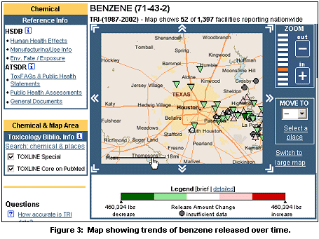
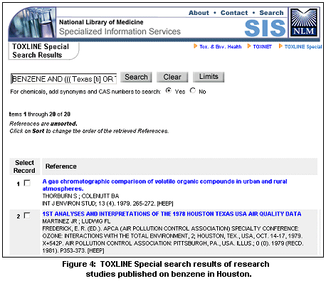
A researcher is aware that the Houston, Texas area is known to contain high concentrations of benzene. He uses TOXMAP to generate a map of that area which shows the most recent data on the released amounts of benzene, as reported in TRI. After studying the map, he asks to see how the amount of benzene released has changed over time by clicking on the Trends tab at the top of the screen. A new map showing trends is generated (see Figure 3). Finally, he is interested in seeing what research studies may have been published relating to benzene in Houston. He clicks on the "Search: chemical & places" link in the Chemical & Map Area box on the left and results from a search of the database TOXLINE Special and PubMed are automatically displayed (see Figure 4).
Scenario 3: Facility Location
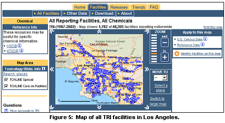
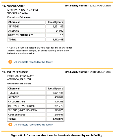
A family is preparing to move to Los Angeles, California, and they want to learn more about environmental health issues in the area. They create a map of all TRI facilities in the area by entering "Los Angeles" in TOXMAP's Quick Search box in the City query box. The search results can be seen in Figure 5. On the right, they click the "Identify facilities on this map" link. When they "identify" the facilities listed on this map, they are presented with information about each TRI chemical released by each facility (see Figure 6).
Additional Reference Information
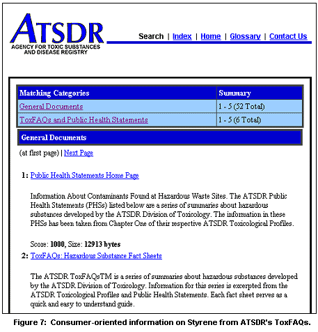
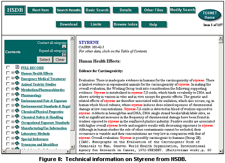
For a consumer-oriented information resource, click on ATSDR (Agency for Toxic Substances and Disease Registry) in the Chemical Reference Info box on the left side of the screen (see Figure 5). Or, for more technical information about the health effects of chemicals, select the link to NLM's Hazardous Substances Data Bank (HSDB), (see Figures 7 and 8 to see results ATSDR and HSDB searches on styrene).
Future Directions
Users of TOXMAP have suggested several additional system features for future releases, such as:
- Multiple chemicals displayed on a single map
- Maps showing releases of one or more types of releases - air, water, land, and/or underground injection
- Tables and graphs of release data (bar charts & pie charts with percentages)
- Updated and expanded U.S. Census demographics (population, race, age, income).
To further enhance TOXMAP's capabilities, users have suggested the addition of many different types of data to overlay with the TRI data. In addition to more demographic data, recommendations include health statistics, superfund sites, water quality data, pesticide usage, floodplain data, and school and neighborhood sites. Users have also requested demographics data at a more granular level (e.g., Census tract). Information that assists with using and interpreting maps is also being considered for future versions of TOXMAP.
More information about TOXMAP can be found at:
http://www.nlm.nih.gov/pubs/factsheets/toxmap.html
and questions about TOXMAP can be sent to: tehip@teh.nlm.nih.gov
By Colette Hochstein
Specialized Information Services

Hochstein C. TOXMAP: A Geographic Information System (GIS) Tool for Exploring Environmental Health Data. NLM Tech Bull. 2005 Jan-Feb;(342):e7.
|