

Location: Cafeteria, Lister Hill Center, Building 38A
Designed and Developed by: Communications Engineering Branch, Lister Hill Center, National Library of Medicine
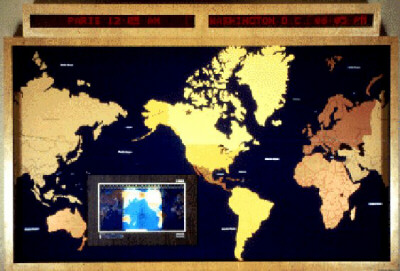
Built in 1981, the system consists of a large electronic (digital) alphanumeric display placed above an 8 ft. by 10 ft. map of the world. The map is physically supported by a wooden base section that houses the power supply and a microcomputer programmed to regulate the large digital display. It is also programmed to calculate the current time in every zone in the world, and both local time and the corresponding time in thirty-three cities around the world are displayed continuously. Recessed within the large world map is a smaller dynamic map called the Geochron, an electromechanical device that provides time zone information, date of the month, day of the week, the sun's noon position, and a daylight/darkness pattern. This last item, the most vivid feature of the Geochron, is an illuminated pattern indicating the relative daylight and darkness areas of the world at any time. The left edge of the lighted map indicates the time of sunrise; the right edge the time of sunset, with this pattern changing shape continuously as the earth progresses through the seasons.
[ Back ] [ Table of Contents ]
Last Reviewed: February 27, 2012